Site Hits: 35,273,345
Site Hits: 35,273,345


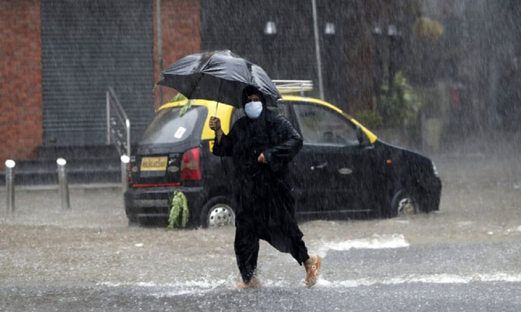
Image Source: News18
The southwest monsoon is set to enter the final leg of its peak period, considered as the months of July and August. Thus far, the country has overall recorded 578.2 mm of rainfall which is 2 per cent above normal, India Meteorological Data (IMD) showed.
The monsoon’s overall countrywide performance though belies the variability seen across regions that has become a regular fixture each year. Along with variability, extreme rain events, seen during the first week of August, have also left their mark.
The spatial and temporal variability of the monsoon manifests and impacts in different ways, ranging from extreme rain events that can cause flash floods as well damage to crops to long dry spells.
This year, the monsoon has been good in eastern India, along the western coast, south peninsular region and central India while it has been uneven in northeast so far. In north and northwest India though rains have been below par across eastern Rajasthan, Delhi, western Uttar Pradesh, Haryana, Punjab and even in the hill states of Uttarakhand, Himachal Pradesh, Jammu and Kashmir and Ladakh, IMD data showed.
In northwest India, the rainfall deficit stands at 21 per cent as on Thursday, August 13. In contrast, rainfall in the south peninsular region comprising of Karnataka, Telangana, Andhra Pradesh, Tamil Nadu and Kerala was 23% above normal, which is considered ‘excess’ rain in meteorological parlance.
The spatial and temporal variability is best illustrated through the performance of the monsoon since its onset.
In June, rainfall across the country was 18 per cent above normal of the long period average (LPA). The LPA is the average rainfall the country receives (880mm) in four months based on 1961-2010 monsoon data. Rainfall in eastern and northeast region and Central India was 16 per cent and 31 per cent above normal. In July though, which is the season’s wettest month, rainfall in the country was 10 per cent below normal.
IMD scientists attributed this below par performance to the absence of any major low pressure area over Bay of Bengal, which is crucial for rainfall in central India and Northwest India. This was also the first time since 1997 that not a single major low-pressure area was seen during this period except a feeble one that was recorded off Odisha’s coast.
D Sivanand Pai, Head, Climate Research & Services, IMD, said, “The typhoons in northwest Pacific feed moisture to the Bay of Bengal which in turn helps in the formation of low pressure areas. These low pressure areas move over eastern, central and northwest India and result in lot of rainfall in July after interacting with winds from the west coast.”
At least four low pressure areas are seen each July and August, the peak monsoon months. However, intense rainfall activity in the first two weeks of August has wiped out much of the deficit in Central India and the country as a whole. The deficit in Northwest India though remains constant.
“We usually see remnants of typhoons moving towards the Bay of Bengal and local conditions also help formation of low pressure area. Neither was seen this time due to unfavourable conditions over the sea,” said Mrutyunjay Mohapatra, Director General, IMD.
The rainfall at district level also gives a picture of the variable monsoon. Out of 685 districts for which IMD’s rain data was available, 287 (42 per cent) districts had received normal rainfall, 182 (26 per cent) districts had received deficient rains, 115 districts (17 per cent) had received excess rain, 81 districts (12 per cent) had received rainfall in large excess and 20 districts (3 per cent) had a large deficit. This shows that while rainfall was in excess or above in 29 per cent districts, it was also deficient or above in an equal percentage of districts.
In addition to the variable monsoon, the country also witnessed extreme rain events which have become another regular feature of the monsoon season. These events are typically marked by large volumes of precipitation in the range of 150mm and above in a 24-hour period. Between August 4 and August 6, the coastal areas of Maharashtra and Kerala and districts in Western Ghats across Karnataka and Tamil Nadu were thrashed by rains.
IMD data showed that in a 24-hour period ending August 6, Vaibhawadi in Sindhudurg district recorded a record 710mm of rain while Avalanchi in Nilgiris dustrict recorded 580mm rains. In urban areas, Mumbai’s Colaba observatory recorded 330mm of rain, which was a record for single-day rainfall. The rains in Mumbai caused rare flooding the southern areas of the city. Last year, the country had recorded 560 extreme rain events as per IMD, Pune.
The Indian government’s crucial report on climate change, ‘Assessment of Climate Change over the Indian Region’, released in June this year has stated that though rainfall has decreased over India in the post-1950 period, global as well as regional models project an increase in seasonal mean rainfall over India even as it projected a weakening monsoon circulation.
At the same time, frequency of extreme precipitation events may increase all over India, especially in central and southern parts as a response to enhanced warming, the report said.


Leave a comment: (Your email will not be published)